La Palma
 Flag of La Palma |
|
| Geography | |
|---|---|
| Location | Atlantic Ocean |
| Archipelago | Canary Islands |
| Area | 706 km2 (272.6 sq mi) |
| Highest elevation | 2,423 m (7,949 ft) |
| Highest point | Roque de los Muchachos |
| Country | |
|
Spain
|
|
| Autonomous Community | Canary Islands |
| Province | Santa Cruz de Tenerife |
| Largest city | Los Llanos de Aridane (pop. 19,659 (2004)) |
| Demographics | |
| Population | 86,528[1] (as of 2008) |
| Density | 122 /km2 (316 /sq mi) |
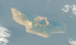
La Palma (Spanish pronunciation: [la ˈpalma]) is located at , making it the most north-westerly of the Canary Islands. La Palma has an area of 706 km2 making it the fifth largest of the seven main Canary Islands. The total population is about 86,000, of which 18,000 (2003 data) live in the capital, Santa Cruz de la Palma and about 20,000 (2004 data) in Los Llanos de Aridane.
La Palma, like the other islands of the Canary Island archipelago, is a volcanic ocean island. The volcano rises almost 7 km (4 mi) above the floor of the Atlantic Ocean. There is road access from sea level to the summit at 2,423 m (7,949 ft),[1] which is marked by an outcrop of rocks called Los Muchachos ("The Lads"). This is the site of the Roque de los Muchachos Observatory, one of the world's premier astronomical observatories.
La Palma's geography is a result of the volcanic formation of the island. The highest peaks reach over 2,400 m (7,874 ft) above sea level, and the base of the island is located almost 4,000 m (13,123 ft) below sea level. The northern part of La Palma is dominated by the Caldera de Taburiente, with a width of 9 km (6 mi) and a depth of 1,500 m (4,921 ft). It is surrounded by a ring of mountains ranging from 1,600 m (5,249 ft) to 2,400 m (7,874 ft) in height. Only the deep Barranco de las Angustias ("Valley of Fear") canyon leads into the inner area of the caldera which is a national park. It can be reached only by hiking. The outer slopes are cut by numerous gorges which run from 2,000 m (6,562 ft) down to the sea. Today, only few of these carry water due to the many water tunnels that have been cut into the islands structure.
In 1815, the great German geologist Leopold von Buch visited the Canary Islands. It was as a result of his visit to La Palma and Tenerife where he visited the Las Cañadas and Taburiente calderas, that the Spanish word for cauldron - "Caldera" - was introduced into the geological vocabulary.
From the Caldera de Taburiente [2] to the south runs the ridge Cumbre Nueva. The southern part of La Palma is dominated by the Cumbre Vieja, a volcanic ridge formed by numerous volcanic cones built of lava and scoria. The Cumbre Vieja is active - but dormant, with the last eruption occurring in 1971 at the Teneguia vent which is located at the southern end of the Cumbre Vieja - Punta de Fuencaliente, (The Point of the Hot Fountain).
La Palma is dominated by the colours blue, green and black. Blue represent the surrounding ocean, Green represents the abundant plant life (which is the most diverse in the Canary Islands) and Black comes from the volcanic rocks that forms the landscape and the numerous playas (beaches) of black sand.
La Palma is nicknamed "Isla Bonita" [3] ("beautiful island") and the "island of San Pedro" (after its patron Saint: Peter). San Pedro is also a music venue on the island where international bands play[4], something which may be referred to in La Isla Bonita.
Santa Cruz de La Palma (the island's main port) retains many elegant 17th and 18th century houses, and produces high quality hand made cigars made from locally grown tobacco.
Contents |
Government
The island is part of the province of Santa Cruz de Tenerife. The island is divided into 14 municipalities:
|
|
Volcano
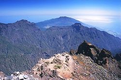
Like all of the Canary Islands, La Palma originally formed as a seamount through submarine volcanic activity. La Palma is currently the most volcanically active of the Canary Islands and was formed three- to four-million years ago. Its basement lies almost 4,000 metres below sea level and reaches a height of 2426 metres. About a half-million years ago, the volcano, Taburiente, collapsed with a giant landslide, forming the Caldera de Taburiente. Historic eruptions (those since the Spanish occupation) have occurred seven times:
- 1470-1492 Montaña Quemada
- 1585 Tajuya near El Paso
- 1646 Volcán San Martin
- 1677 Volcán San Antonio
- 1712 El Charco
- 1949 Volcán San Juan, Duraznero, Hoyo Negro
- 1971 Volcán Teneguía
During the 1949 eruption from the Duraznero, San Juan, and Hoyo Negro vents on the Cumbre Vieja, an earthquake, with an epicentre near Jedy, occurred. This caused a 2.5 kilometre-long rift to open, with a width of about a metre and a depth of about two metres (Rubio Bonelli, 1950).
In a BBC Horizon program broadcast on October 12, 2000, two geologists (Day and McGuire) cited this rift as proof that half of the Cumbre Vieja had slipped towards the Atlantic Ocean (Day et al., 1999; Ward and Day, 2001). They suggested that this process was driven by the pressure caused by the rising magma heating water trapped within the structure of the island. They hypothesised that during a future eruption, the western flank of the Cumbre Vieja, with a mass of approximately 1.5 x10¹⁵ kg, could slide into the ocean. This could then potentially generate a giant wave which they termed a "megatsunami" around 650–900 m high in the region of the islands. The wave would radiate out across the Atlantic and inundate the eastern seaboard of North America including the American, the Caribbean and northern coasts of South America some six to eight hours later. They estimate that the tsunami will have waves possibly 1,000 ft (305 m) or more high causing massive devastation along the coastlines. Modeling suggests that the tsunami could inundate up to 25 km (16 mi) inland - depending upon topography. The basis for Ward and Day (1999) modeling the collapse of a much larger portion of the western flank than the currently visible surface fissures suggest is unstable was evidence from geological mapping by Day et al. 1999. In this paper they argue that a large part of the western flank has been constructed in the scar of a previous collapse and therefore sits upon unstable debris.
The claim was also explored in a BBC docu-drama called End Day which went through several hypothetical scenarios of disastrous proportions.
However, the Tsunami Society (Pararas-Carayannis, 2002), published a statement stating "... We would like to halt the scaremongering from these unfounded reports ..." The major points raised in this report include:
- The claim that half of Cumbre Vieja dropped 4 m (13 ft) during the 1949 eruption is erroneous, and contradicted by physical evidence.
- No evidence was sought or shown that there is a fault line separating a "block" of La Palma from the other half.
- Physical evidence shows a 4 km (2 mi) long line in the rock, but the models assumed a 25 km (16 mi) line, for which no physical evidence was given. Further, there is no evidence shown that the 4 km (2 mi) long line extends beyond the surface.
- There has never been an Atlantic megatsunami in recorded history.
Other workers also disagree with the hypothesis of Day et al.; (1999) and Ward and Day (2001). In fact no scientists have expressed support for their speculations.
There is however, a consensus by geologists and volcanologists that edifice failure (large-scale collapses or mass wasting) of volcanic islands does occur and that large tsunamis have occurred in the Atlantic in the geological past. Despite this there is still no evidence reliably proving a cause and effect. All the documented large scale tsunamis in the Atlantic have been verifiably attributed to underwater earthquakes and not island collapses. Evidence of Tsunami deposits has been reported from the Caribbean and the Canary Islands. Since the 1990s the area has been (and continues to be), monitored and no movement has been detected. Ongoing and recent (2008) monitoring shows that the dimensions accord with those recorded in 1949. Thereby indicating that the block has not moved since 1949. Controversial evidence on the island of Bermuda is said to be tsunamite deposited by a tsunami that was generated by edifice failure on the adjacent island of El Hierro.
The actual distances involved in the 1949 rift are as follows: horizontal ~1 metre, vertical ~2 metres. Volume involved of the whole of the Cumbre Vieja is ~5 x 10¹¹ m3 with an estimated mass of 1.5 x 10¹⁵ kg.
Economy
The local economy is based on a variety of things including: tourism and agriculture. Platanos (or Bananas) are grown throughout the island with many banana farms found on the western side of the island in the valley of Los Llanos de Aridane. Other plants include: Strelitzia (or 'Bird of Paradise') flowers, avocados, and grapes (which are grown well in the volcanic soil). The wine from the grapes is prized. Local ranchers have other herds such as cows and goats (from which they make goat cheese).
Fisherman in 'Puerto Naos' will catch fish to sell at the market.
Flora and fauna
As with all the Canary Islands, La Palma has several endemic species.
Although large areas have been deforested, the upland areas of La Palma retain some of the temperate cloud forest, or laurisilva (laurel forest), dominated by Laurus, but including Juniperus cedrus (Canary Islands Juniper) and other trees. This is a relic of the Pliocene subtropical forests which used to cover all the Canary Islands.
The Canary Island Pine (Pinus canariensis) is endemic to all the Western Canary Islands, whilst Genista stenopetala, or sweet broom and Spartocytisus supranubius, a white broom known locally as Retama del Teide, are native to La Palma and Tenerife. Echium webbii, a variety of Echium virescens (Tower of jewels) is endemic to La Palma, as are Ceropegia fusca and Ceropegia dichotoma; varieties of Cardoncillo.
Several animals are native or endemic to La Palma, including the:
- La Palma Giant Lizard, believed extinct until rediscovered in 2007
- Western Canaries Lizard Gallotia galloti, subspecies palmae
- Graja (Pyrrhocorax pyrrhocorax barbarus), subspecies of the Red-billed Chough
- Canary Islands Chiffchaff (Phylloscopus canariensis)
- La Palma Chaffinch (Fringilla coelebs palmae)
- Western Canary Islands Goldcrest (Regulus regulus ellenthalerae)
- Canary Islands Quail (Coturnix gomerae)
In addition, many other animals have been introduced, including rabbits and Barbary Sheep, or Aoudads, which have become a serious threat to endemic flora
A biosphere reserve was established in 1983, and extended and renamed in 1997 and 2002
History
At the time of European colonization, the Canary Islands were inhabited by native Canarians, referred to collectively as Guanches, although the natives of La Palma are more correctly known as Auaritas (See Canary Islands in pre-colonial times). The origin of these natives is unclear but they are believed to share common ancestry with the Berbers of North Africa. The Guanches had a Neolithic culture divided into several clans led by chiefs. Their name for La Palma was Benahoare. The main remnants of this culture are their cave dwellings, enigmatic petroglyphs and paved stone paths through the mountains. After the Spanish occupation of La Palma, the native Canarians vanished by either being killed, sold into slavery or by assimilating into the Spanish population.
It is believed that the Canary Islands were known to the Phoenicians and Greeks, but the earliest written evidence is by the Roman writer Pliny The Elder, who quoted Juba II of Numidia, but Juba's writings were subsequently lost. The Genoese navigator Lancelotto Malocello reached the archipelago in 1312 and remained for two decades until expelled by a native uprising. In 1404 the Spaniards began the conquest of the islands. Though the first landing on La Palma was in 1405, it took until 1493 and several bloody battles until the last resistance of the natives was broken. The conqueror of La Palma was Alonso Fernández de Lugo, who defeated Tanausu, the last king on the island. He ruled the area known as Acero (Caldera de Taburiente). Tanausu was ambushed after agreeing to a truce arranged by Fernández de Lugo and Juan de Palma, a Guanche who had converted to Christianity and who was a relative of Tanausu.
For the next two centuries, settlements on La Palma became rich as the island served as a trading post on the way to the New World. La Palma received immigrants from Castile, Portugal, Majorca, Flanders, and Catalonia.
Local Population
The local population include: merchants, farmers, fisherman, and tourism workers.
It is very common to see the men in the town with red spots on their shirts (due to staining from the banana sap) that occurs during harvesting and processing of the bananas. They enjoy Lucha Canaria (Canary style wrestling) as well as cock fighting and remote controlled cars. The local balconies of the houses are very ornate and are hundreds of years old. They enjoy salsa music and canarian cuisine.
Religion
Most of the island is predominately Catholic. It is known, since 1676, for the festival of "La Bajada de la Virgen de las Nieves" (The taking/coming down of the virgin of the snow, Candelaria). It is rich in history, starting from the time of the Bishop of the Canaries, Bartolomé García Ximénez. The festival features the dancing of "enanos" or midgets. The costumes that people wear have a hole at the top of the hat to allow them to see out, while giving the appearance of dancing midgets. People come from all over the world for the celebration which happens every few years. The image of the virgin is taken down from her sanctuary and paraded around the city with the festival for nearly two weeks and then returns.
Each island has a patron saint and "Virgen de las Nieves" (Virgen of the snow) is the patron saint of La Palma. Many women on the island have the name "Nieves" in honor of this.
Transport
La Palma has a road network of some 1,200 km (746 mi). All the main roads are asphalted and in a good state, although there are many sharp bends, some very narrow. In order to reach some small hamlets in the north of the island it is necessary to travel on earth tracks. A good paved road approximately 180 km (112 mi), circumscribes the island. Several bus routes exist that unite the main localities on the island; for more details see [1].
There is a road that runs from Los Llanos de Aridane to the capital city of the island Santa Cruz de La Palma (known by locals as simply La Palma). This road is a two lane highway that includes a two lane tunnel that goes right through the top of the mountain. When traveling from one side of the mountain to the other it is common to enter one side in complete clouds (the east side) and come out to the sunny side (western side). This is due to the clouds not being able to cross the mountains.
La Palma Airport serves the island, and several airlines run services to and from it. There is also ferry service to and from the island in the city of Sta. Cruz.
Water tunnels
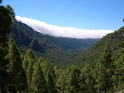
The most famous structures of La Palma are the minas galerias (water tunnels) which carry the water from sources in the mountains to cities, villages and farms (mainly banana plantations). La Palma receives almost all of its water supply due to the mar de nubes (sea of clouds), stratocumulus cloud at 1200–1600 m altitude, carried on the prevailing wind which blows from the north-east Trade Winds. The water condenses on the long needles of the trees and other vegetation, it then either drips onto the ground or runs down the trunk etc., into the ground. Eventually it collects inside the rock-strata, and is then drained via the galerias into aqueducts and pipes for distribution. The galerias have been cut into the rocks over centuries. To visit the galerias a permit is required. It is possible to walk alongside many of the aqueducts, a popular activity for tourists (similar to the levadas of Madeira). The tour to the Marcos y Corderos waterfall and springs is also popular.
There is an extensive network of irrigation canals in the valley of Los Llanos de Aridane. These canals carry water from the mountains throughout the valley and allow for the cultivation of bananas, avocados, flowers, and other plants. Each farmer gets a scheduled "turn" to fill an irrigation tank with water 24 hours of the day. If a farmer's turn is at 2 am he will wake up and make sure to fill his tank when possible so as to have sufficient water for his farm.
These round tanks typically gather moss and lilly pads upon which frogs make their habitat.
Observatories
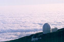
Due to the location of the island and the height of its mountains, some 2,400 m (7,874 ft) above sea level, a number of international observatories have been built on the Roque de los Muchachos. The particular geographical position and climate cause clouds to form between 1,000 m (3,281 ft) and 2,000 m (6,562 ft), usually leaving the observatories with a clear sky. Often, the view from the top of the volcano is a sea of clouds covering the eastern part of the island. Telescopes at the observatory include:
- The Isaac Newton Group of Telescopes (ING) operates three telescopes: the 4.2 m (14 ft) William Herschel Telescope, the 2.5 m (8 ft 2 in) Isaac Newton Telescope and the 1 m (3 ft 3 in) Jacobus Kapteyn Telescope.
- The 2.5 m (8 ft 2 in) Nordic Optical Telescope (NOT).
- The 1 m (3 ft 3 in) Swedish 1-m Solar Telescope (SST) operated by the Institute for Solar Physics.
- The 0.45 m (1 ft 6 in) Dutch Open Telescope (DOT).
- A 0.6 m (2 ft 0 in) optical telescope.
- The Carlsberg Meridian Telescope (CMT).
- The 1.2 m (3 ft 11 in) Mercator Telescope.
- The 2 m (6 ft 7 in) Liverpool Telescope.
- The 10.4 m (34 ft) Gran Telescopio Canarias (Great Canary Telescope, dedicated 24 July 2009).
- The 3.6 m (12 ft) Telescopio Nazionale Galileo (TNG).
- The 17 m (56 ft) MAGIC Telescope, an air shower Cherenkov telescope for observing high energy gamma rays
- The SuperWASP-North telescope, used to detect extrasolar planets.
The DOT and the SST have been specifically built to study the Sun.
See also
- List of volcanoes in Spain
References
- ↑ 1.0 1.1 ISTAC "Instituto Canario de Estadistica" (In Spanish). Retrieved April 24, 2009
- ↑ Photo: Crater of Taburiente, Official Tourism Office of the Canary islands
- ↑ Walks in La Palma, La Isla Bonita
- ↑ La Isla Bonita
Anthrax at San Pedro, La Isla Bonita
- Bonelli Rubio, J.M., 1950. Contribucion al estudio de la erupcion del Nambroque o San Juan. Madrid: Inst. Geografico y Catastral, 25 pp.
- BBC 2 TV; 2000. Transcript “Mega-tsunami; Wave of Destruction”, Horizon. First screened 21.30 hrs, Thursday, 12 October 2000.
- Carracedo, J. C; 1994. The Canary Islands: an example of structural control on the growth of large oceanic-island volcanoes. J. Volcanol. Geotherm Res. 60, 225-241.
- Carracedo, J. C; 1996. A simple model for the genesis of large gravitational landslide hazards in the Canary Islands. In McGuire, W: Jones, & Neuberg, J. P. (eds). Volcano Instability on the Earth and Other Planets. Geological Society, London. Special Publication, 110, 125-135.
- Carracedo, J. C; 1999. Growth, Structure, Instability and Collapse of Canarian Volcanoes and Comparisons with Hawaiian Volcanoes. J. Vol. Geotherm. Res. 94, 1-19.
- Day, S. J; Carracedo, J. C; Guillou, H. & Gravestock, P; 1999. Recent structural evolution of the Cumbre Vieja volcano, La Palma, Canary Islands: volcanic rift zone re-configuration as a precursor to flank instability. J. Volcanol. Geotherm Res. 94, 135-167.
- La erupción del Nambroque : (junio-agosto de 1949) / por José Romero Ortiz y Juan Mª Bonelli Rubio Madrid : Talleres del Instituto Geográfico y Catastral, 1951 100 p., 1h. pleg.;23 cm
- Moore, J. G; 1964. Giant Submarine Landslides on the Hawaiian Ridge. US Geologic Survey Professional Paper 501-D, D95-D98.
- Pararas-Carayannis, G; 2002. Evaluation of the Threat of Mega Tsumami Generation from Postulated Massive Slope Failure of Island Stratovolcanoes on La Palma, Canary Islands, and on The Island of Hawaii. Science of Tsunami Hazards, Vol 20, No.5, pp 251–277.
- Rihm, R; Krastel, S. & CD109 Shipboard Scientific Party; 1998. Volcanoes and landslides in the Canaries. National Environment Research Council News. Summer, 16-17.
- Siebert, L; 1984. Large volcanic debris avalanches: characteristics of source areas, deposits and associated eruptions. J. Volcanol. Geotherm Res. 22, 163-197.
- Ward, S. N. & Day, S. J; 2001. Cumbre Vieja Volcano; potential collapse and tsunami at La Palma, Canary Islands. Geophys. Res. Lett. 28-17, 3397-3400. http://www.es.ucsc.edu/~ward/papers/La_Palma_grl.pdf
- van Nieuwkoop, J, 2006. Technical University of Delft. Landslide in La Palma will not lead to mega-tsunami. http://www.tudelft.nl/live/pagina.jsp?id=3000b5ea-cdb6-421e-841c-d63d5aa73a39&lang=en
- Prof. Dr. Nieuwenhuis, J.D, Ir. van Berlo, J, Ir. Labeur, R.J, Technical University of Delft. The day the world ended. La Palma megatsunami suffers a slight delay. http://www.tudelft.nl/live/pagina.jsp?id=4096f2de-bb4e-4d1f-830f-45d19de32940&lang=en
External links
La Palma island
- Official Tourism Website
- Official La Palma Website (Spanish)
- La Palma - The official website of the Canary Islands
- La Palma's On-line Community with Tourist Information
- La Palma tourist info, advice and photos based on our own experiences
- discussion
- Information and 1000+ photographs
- Instituto de Astrofísica de Canarias (Spanish)
- Interactive 360° panoramic photographs of La Palma in QuickTime VR and Java VR
- La Palma, Canary Islands - data and lots of pictures
- La Palma Diashow
- La Palma Gallery - Diashows, Landscapes, Impressions
- Panoramic Photos La Palma
- Another La Palma Gallery - Landscapes
Megatsunami threat?
- La Palma Tsunami The mega-hyped tidal wave story
- Scientists warn of massive wave
- Tidal wave threat 'over-hyped'
|
|||||||
|
|||||||||||||